yahoo Press
Severe thunderstorms, tornadoes, hail to strike Oklahoma: Live radar, timing
Images
1 / 9
2 / 9

3 / 9

4 / 9

5 / 9

6 / 9

7 / 9

8 / 9

9 / 9
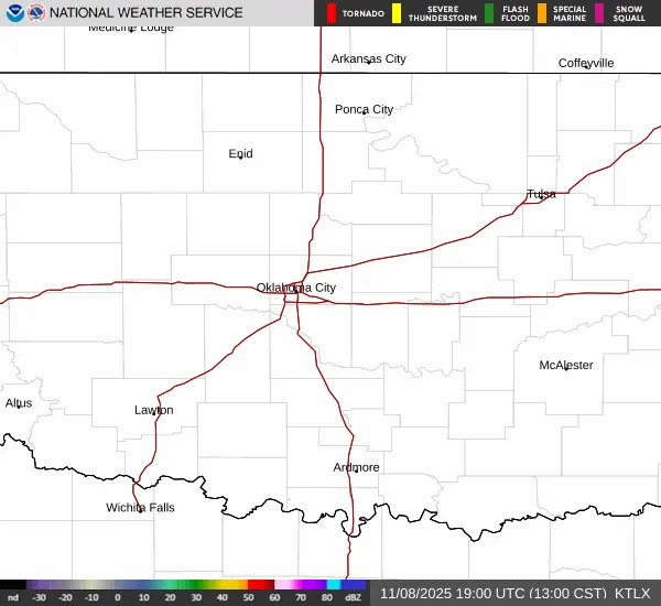
Severe weather is back on the menu.

Through this afternoon and evening, Oklahoma will face thunderstorms that can produce hail, damaging winds, and tornadoes. Meteorologists aren't yet sure how far south dangerous storms will be able to form, but any that do will present all hazards.

Later in the weekend, a cold snap will bring low temperatures down into the 30s.

Here's what to expect in Oklahoma City, and throughout the state, on Friday, April 17.

A cold front will move south through Oklahoma on Friday across a dryline and into warm, moist air. This setup is ideal for creating thunderstorms, especially supercell storms that can produce large hail and strong tornadoes.

These thunderstorms will most likely form in northern Oklahoma after 3 p.m., according to the National Weather Service in Norman. As the front moves south, it will create more chances for thunderstorms in and around Oklahoma City.

Any storms that form in central Oklahoma are expected sometime after 5 p.m., but are most likely to form between 9 p.m. and 2 a.m.

The overall tornado threat for Oklahoma, however, is considered "low." The best chance for tornadoes to form will be further north into the Midwest and Great Lakes region.

In a forecast issued Friday morning, NWS said it's not yet clear whether severe storms will form across the dryline in central Oklahoma and south of Interstate 40.

If these storms can form, however, the atmosphere is primed for a strong tornado threat. Make sure you remain weather-aware and have a way to get storm alerts.

Meteorologists will be closely watching for the appearance of convective storms south of I-40.

The same cold front that will create strong thunderstorms in Oklahoma will bring chilled air behind it.

Northerly winds of 20-30 mph are expected through Saturday morning, with gusts up to 50 mph in western and southwestern Oklahoma near Altus. The NWS expects wind gusts of 40 mph in Oklahoma City.

Along with the cold front will be a general cool-down in Oklahoma with highs in the 60s. Overnight lows, especially on Sunday morning, will be chilly and will reach down into the 30s. Forecasters expect to consider issuing freeze-related alerts if the cooling trend continues or strengthens.

Low humidity and high winds will contribute to the ongoing risk of wildfire in western and northwestern Oklahoma through the weekend.

NWS expects to see elevated to near-critical fire weather conditions, even though the current red flag warning expires Friday night.

This article originally appeared on Oklahoman: Severe storms, hail to strike Oklahoma on Friday: See radar, tornado chances