yahoo Press
Northern California rarely gets thunderstorms. But the next few days will be different
Images

1 / 13
2 / 13

3 / 13

4 / 13
5 / 13

6 / 13
7 / 13
8 / 13
9 / 13
10 / 13

11 / 13

12 / 13

13 / 13
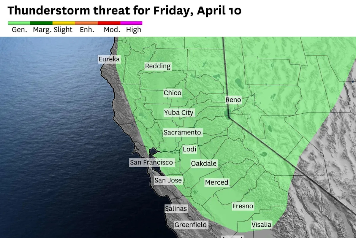
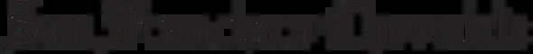
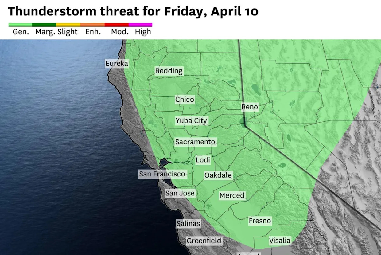
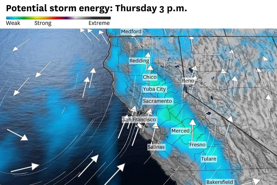
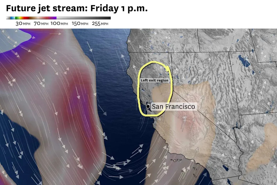
A weather pattern highly conducive to Northern California thunderstorms will kick off in earnest Thursday and last through at least Saturday. Storms will become more numerous each day, posing a threat of frequent cloud-to-ground lightning, hail, erratic winds and even a chance of funnel clouds and tornadoes.

Northern California generally has far less lightning than other parts of the country, but ingredients for thunderstorms don't get much better than what's forecast over the next few days.

A broad, slow-moving system known as a cutoff low has been inching toward California all week. It was close enough Wednesday to create towering cumulonimbus clouds and trigger thunderstorms over the mountains, but its proximity Thursday should introduce the potential for storm cells in coastal and valley areas, too.

There are four main ingredients for thunderstorms to form: moisture, instability, wind shear and a trigger.

Moisture should be abundant Thursday through Saturday as the cutoff low spins subtropical air over California. This humid air means downpours could drop a quarter to a half-inch of rain in an hour or less, enough to cause brief flooding.

Instability is a measure of how unsettled the atmosphere is, when air parcels lower in the atmosphere remain warmer and more buoyant than the air above them, and keep trying to rise. This vertical motion is key for thunderstorm development.

Instability is expected to increase Thursday and be maximized on Friday in the Central Valley, Wine Country and East Bay interior valleys. A marine layer will probably keep the coastal air stable until late Friday or Saturday, when it may finally erode and open the door for thunderstorms in San Francisco.

Wind shear - a change in wind direction and/or speed in the atmosphere - will gradually increase in the coming days as the cutoff low nudges closer. The counterclockwise-spinning air around the low's center will encourage "rotating storms capable of producing tornadoes," the National Weather Service said.

Those ingredients can all be prevalent and no thunderstorms will form if there is not something to trigger, or pop, a storm.

Mountainous areas of Northern California typically experience the most thunderstorms because they tower above the cool, stable marine air that inhibits vertical motion. Air can flow up mountain slopes during the day, which pops storms. But as the cutoff low moves closer, particularly on Friday, it will provide rising air away from mountainous areas, too.

A second, more energetic system will arrive Saturday and swing a cold front across Northern California, providing the strongest trigger for downpours and thunderstorms yet, but clouds ahead of it may limit how unsettled the air is. Still, it should bring at least a few hours of heavy rain, wind gusts up to 45 mph and feet of snow to the Sierra Nevada.

Saturday's storm is trending stronger.

"We are monitoring for increased ponding on roadways and potential localized urban flooding during peak intensity," said Roger Gass, a meteorologist at the Monterey weather service office.

San Francisco: Low clouds and fog could squeeze out drizzle in the morning but partial clearing is expected midday. Highs will reach the low 60s in the Richmond and Sunset districts, Lakeshore, the Presidio and the Marina and the mid- to upper 60s elsewhere. Rain showers are possible in the late afternoon and evening with a better chance overnight. Lows will be in the mid- to upper 50s.

North Bay: Showers will gradually increase throughout the day, with the best chance in Sonoma and Marin counties in the morning and eastern Solano County in the afternoon. Thunder and lightning are possible, most likely over the mountains and close to the Central Valley. Dry, sunny periods will outweigh the rain, though, allowing temperatures to reach the upper 60s to low 70s. Solano County could reach the mid-70s. Coastal areas will be closer to 60 degrees. Overnight lows will be in the low to mid-50s with increasing shower chances.

East Bay: Isolated showers are possible anywhere, with the greatest chances in eastern Contra Costa County in the afternoon and western Alameda County overnight. However, many places may stay completely dry. The heaviest showers could be accompanied by thunder and lightning. Highs will be in the mid- to upper 60s west of the Caldecott Tunnel and the low 70s in the inland valleys. It'll be breezy in the afternoon, with gusts up to 20 mph. Overcast skies will keep overnight lows warm, in the mid-50s, with a chance of rain.

Pacific Coast and Peninsula: Hit or miss showers are possible at any time of the day, though many places may remain dry. No more than a quarter of an inch of rain is expected. The morning will start foggy at the coast before partial clearing midday. Rain chances will increase overnight. Highs will be in the upper 50s to mid-60s at the coast and upper 60s to low 70s in South San Francisco, San Bruno, San Mateo and Redwood City. Lows will be in the mid-50s.

South Bay and Santa Cruz: Overcast skies are expected in Santa Clara and Santa Cruz counties, capping highs in the low to mid-70s in the South Bay and Santa Cruz Mountains and the mid- to upper 60s along the Monterey Bay coastline. Isolated showers are possible any time of day, but will become more numerous overnight. Lows will be in the mid- to upper 50s.

This article originally published at Northern California rarely gets thunderstorms. But the next few days will be different.